Skip to content Skip to left sidebar Skip to footer

GSP Updates

Stakeholders can review a full draft Groundwater Sustainability Plan, now available for download

At the July 17th Board Meeting, the North Fork Kings GSA Board approved opening the draft Groundwater Sustainability Plan (GSP) 90-day public review and comment period. Members of the public are encouraged to download the GSP on the website at northforkkings.org/gspcomment and provide comment for the agency’s consideration.

The GSP includes potential policies and projects that will impact groundwater management in the region for years to come as the North Fork Kings GSA works to achieve sustainable groundwater supply. Technical consultants worked over the last two years collecting data that documents historic and current groundwater conditions; the GSP uses this information as the foundation to define a path forward for how groundwater will be managed.

The North Fork Kings GSA will use the GSP as a roadmap to balance its estimated 59,000 acre-feet of annual groundwater overdraft by 2040. The overdraft can be balanced using both supply-side and demand-side solutions. The toolkit of projects and management actions will include both, but the North Fork Kings GSA Board plans to prioritize supply-side solutions including floodwater capture for groundwater recharge.

Members of the public are encouraged to take part in the important process of defining the path forward toward groundwater sustainability. The public comment period will conclude at the end of the day on October 21st.

The North Fork Kings GSA is hosting workshops in August to review what is in the GSP and how it impacts those with a stake in groundwater management. View the GSP calendar for workshop details: GSP Calendar.


Click below to download the GSP and find more info regarding the Public Review period.

Ready to comment? Click below to access our online comment form.

Our water needs a budget

Water is scarce. Sustainability of the resource we all depend on requires balanced inputs and outputs. Whether SGMA is the compulsion or not, responsibly managing water demands a budget.

In the Kings Subbasin we’re working to balance an overdrafted water “account”. The North Fork Kings GSA, along with the six other GSAs in the Kings Subbasin, is required by SGMA to bring its account into balance by 2040.

A water budget, required in the Groundwater Sustainability Plan (GSP),  provides valuable insight for those managing our water. It informs current conditions and will measure impact of the North Fork Kings GSA’s upcoming sustainability efforts.

The budget tracks water inputs and outputs to calculate the change in groundwater storage in the service area. A negative groundwater storage indicates overdraft.

Groundwater Storage = Inputs – Outputs

Sustainability can be achieved by increasing water supply (inputs) and/or decreasing water demand (outputs). The GSP will define how the North Fork Kings GSA plans to balance its estimated 50,300 AF of annual overdraft. The GSA can increase its inputs, decrease its outputs, or a combination of both through projects and management actions. For example increasing inputs through flood water capture off the Kings River in wet years can offset irrigation outputs, bringing the budget closer to balance.

Inputs are water sources, and can include additional surface water, precipitation, estimated groundwater pumping, and groundwater inflow. Outputs are water uses, and can include irrigation, municipal, residential, and industrial uses, as well as groundwater outflow. The North Fork Kings GSA is committed to prioritizing supply side solutions for sustainability.

Water Budget Diagram

click to enlarge

A water budget is a key component of the Groundwater Sustainability Plan (GSP), and will be included in the draft document scheduled for public review beginning in July.

When Water Supply is Scarce, Management Actions can Mitigate Overdraft

There are only two ways to achieve sustainability and eliminate groundwater overdraft for the North Fork Kings service area: increase water supply, primarily through project development and reduce water demand, primarily through management actions. The NFKGSA Board is emphasizing increasing water supply with the understanding there are hurdles to overcome.

The preliminary project list continues to be updated and contains recharge projects that would yield an estimated annual average of approximately 50,000 acre feet per year based on historic floodwater availability. The seven Kings Subbasin GSAs have reached agreement on an initial overdraft amount for the entire Kings Subbasin of 122,000 acre feet. The North Fork Kings GSA estimated amount of the 122,000 acre feet is 50,300 acre feet. 

The amount of overdraft that cannot be overcome with increasing the water supply will need to be overcome with management actions that reduce water demand.  Demand reduction through management actions will likely need to be initiated within 5 – 10 years if project development isn’t progressing as needed.

Management Actions are programs and policies that will aid the GSA in achieving sustainability primarily through water demand reduction measures and improving data monitoring.  A suite of potential management actions will be presented in the GSP that could be implemented at the GSA level or landowner level. The GSA may not want to dictate management actions at the landowner level, what works for one landowner may not work for another and economic impacts must be considered.

Below are potential management actions that will be considered in the GSP and the estimated time for implementing those actions.

Management Actions for the 2020-2025 Timeframe


click to enlarge

Management Actions for the 2025-2030 Timeframe


click to enlarge

Management Actions for the 2030-2040 Timeframe

click to enlarge

Discussions and the development of the management actions details will begin after the adoption of the GSP in January 2020.

Proposed project would recharge an estimated 15,000 AF annually in the North Fork Kings GSA

A portfolio of solutions will be considered to achieve sustainable groundwater under SGMA. Projects and management actions can work in tandem to augment water supply and reduce water demand, stabilizing groundwater levels. The North Fork Kings GSA Board’s first priority is implementing projects to increase water supply in the service area. The North Fork Regional Recharge Project introduced by Kevin Johansen, Provost & Pritchard, aligns with that priority. The project is in early conceptual stages.

Three groundwater recharge basins with estimated annual recharge capacity of 15,000 AF (acre-feet) are included in the project scope, leveraging suitable recharge conditions in the GSA’s northeast region. The average annual cost per AF of recharge is $160 according to preliminary project cost estimates. The project includes two new basins and expansion of an existing Laguna Irrigation District basin. An additional component needed is improvement and expansion of Liberty Canal to increase current carrying capacity and secure water delivery.

Surface soil type, absence of clay layers, and groundwater flows at project sites are highly conducive to recharge that benefits the entire GSA’s service area. The bulk of surface soils at proposed sites are coarse sands and sandy loam, ideal for percolation into the groundwater aquifer below. And although much of the GSA is underlain with clay layers, the northeast region is absent of these layers. Because groundwater generally flows east to west in the GSA, the groundwater recharged by the project would flow into the rest of the service area. This includes to disadvantaged communities of Lanare and Riverdale where soil type and clay layers are unsuitable for recharge projects.

(click map images to enlarge)

To help cover project cost, the North Fork Kings GSA is pursuing grant funding through Integrated Regional Water Management (IRWM) Prop 1 Implementation funds. A pre-application was sent to the Kings Basin Water Authority for review and if selected, will compete for funding from a pool of $12.7 million for the Tulare Kern Funding Area.

Update on water quality in the North Fork Kings GSA, consultant reviews the data

The latest Groundwater Sustainability Plan (GSP) update from the North Fork Kings GSA technical consultants lends insight into the current water quality condition in the GSA service area. Water quality is an indicator of groundwater sustainability. The North Fork Kings GSA will establish sustainability criteria for water quality in its GSP, defining the level of water quality that must be maintained by 2040.

The analysis of water quality data reveals despite lowering groundwater levels, water quality contaminant levels have not worsened over time. But exceedances in maximum contaminant levels (MCL’s) do exist in some areas.

The GSA’s consultant conducted an analysis of publicly available Groundwater Ambient Monitoring and Assessment Program (GAMA) data from 73 wells located in the GSA. This analysis focused on the most recent 10-year period, with some earlier historical data included when available. The black circles on the map below indicate wells with water quality data used in the analysis.

Water Quality Monitoring Network
(click to enlarge)

The water quality data drawn from the wells in the North Fork Kings GSA was measured against the Environmental Protection Agency’s (EPA) primary maximum contaminant levels (MCL’s) and secondary MCL’s. Contaminants without MCL’s were measured against health-based screening levels.

EPA’s primary MCL: legally enforceable standards that apply to public water system and protect public health by limiting levels of contaminants in drinking water

EPA’s secondary MCL: non-enforceable guidelines regulating contaminants that may cause cosmetic effects or aesthetic effects. This is the EPA’s recommended standard, but is not required

The water quality data can be analyzed two ways: by contaminants’ level of exceedance (Table 1) or by existence of contaminants in aquifer “zones” (Table 2).

Table 1
contaimants’ level of exceedance
Table 2
contaminant existence by zone

Existing clay layers in the North Fork Kings GSA allow the division of three conceptual aquifer “zones”: 1) the shallow zone exists from 0-150 feet below ground surface, 2) the intermediate zone exists from 150 feet below ground surface to the base of the unconfined aquifer, and 3) the deep zone exists below the unconfined aquifer. Table 2 above shows that there is not necessarily one zone with water quality exceedances more problematic than another.

Each contaminant’s existing levels can be analyzed individually using separate maps for each aquifer zone. The maps indicate contaminant levels with green, yellow, and red markers. Green indicates contaminant levels are less than half of the MCL. Yellow indicates contaminant levels are more than half or approaching the MCL. Red indicates contaminates are in exceedance of the MCL.

Case Example: Arsenic

Shallow

Image 1 of 3

Click images to enlarge.

The maps show that there are more arsenic MCL exceedances in the intermediate zone, with exceedances concentrated near the center of GSA.

Case Example: Nitrates

Shallow

Image 1 of 3

Click images to enlarge.

The nitrate maps indicate few MCL exceedances in the shallow zone, only a couple in the intermediate, and a single instance in the deep zone.

Understanding water quality in the GSA through data analysis is a key step toward setting metrics that guide the North Fork Kings GSA sustainability efforts and indicate success. Water quality is a sustainability indicator; the GSA will establish a measurable objectives for water quality that quantify the level to maintain by the year 2040.

(click to enlarge)

Preliminary Overdraft Number for NFKGSA Released

The seven Kings Subbasin GSAs have reached agreement on an initial overdraft amount for the Kings Subbasin of 122,000 acre feet. The North Fork Kings GSA estimated amount of the 122,000 acre feet is 50,300 acre feet. The North Fork Kings GSA  Board has already identified potential projects to begin correcting the target overdraft amount by the SGMA sustainability deadline of 2040.

There are two basic ways to achieve sustainability and eliminate overdraft: increase water supply or reduce water demand. The Board’s first priority is to increase water supply, but there are hurdles for this course of action within the North Fork Kings area including availability and frequency of additional water; all Kings River water is allocated through a water rights schedule; and the service area has physical constraints for recharge including soil types and a limited distribution system.

The map below (click map to enlarge) shows the general soil types in the North Fork Kings GSA. The green areas in the eastern portion of the GSA are sandier soils and more conducive for recharging the aquifer. The western portion has heavier clay soils that are more impermeable and consequently poor for recharge.

Although the eastern part of the service area has better soils for recharge, it lacks a distribution system. Therefore, infrastructure needs to be constructed to deliver water to any future recharge projects that may be built. The map below (click map to enlarge) represents significant surface water features in the North Fork Kings GSA.

North Fork Kings GSA preliminary project list contains nine groundwater recharge projects yielding an estimated annual average of approximately 20,000 acre feet per year. Additional projects will need to be identified to alleviate the overdraft amount. If water supply tactics are not sufficiently successful to eliminate the 50, 300 acre feet overdraft number then management actions to reduce water demand will need to be implemented.

Increasing data-driven groundwater management is needed under SGMA; DWR technical services can support that effort

At the October 24th Board Meeting the North Fork Kings GSA Board approved to submit an application for Technical Support Services from the CA Department of Water Resources (DWR) in a move to solve data gaps in the monitoring network. Services available through DWR include the installation of dedicated monitoring wells and video logging to gather construction information on existing wells among others.

Sustainability mandates under SGMA necessitate data-driven groundwater management. A Groundwater Sustainability Plan requirement, the monitoring network is a key data gathering component for establishing and monitoring sustainability goals in the North Fork Kings GSA. Data collected from the network of monitoring wells must be reported annually to DWR; the data will also be an important metric for the North Fork Kings GSA to measure the impacts and results of future projects and management actions on groundwater levels within the service area.

Current groundwater condition insights are drawn from existing monitoring programs including CASGEM (California Statewide Groundwater Elevation Monitoring) and GAMA (Groundwater Ambient Monitoring and Assessment Program), but increased data capacity is needed to sufficiently monitor sustainability progress and ensure the GSA is achieving its mitigation targets.

The GSAs technical consultant, Kevin Johansen of Provost & Pritchard recommends a network density of 2-3 monitoring wells per township. Because of the hydrogeologic variability of the area, which includes multiple clay layers, a confined aquifer, and an unconfined aquifer (unconfined aquifer exists in the absence of clay layer), sufficient network density is important in the North Fork Kings GSA.

The map pictured below illustrates current gaps in the North Fork Kings GSA monitoring network. (Please note the image is a DRAFT.)

North Fork Kings GSA Well Network and Data Gaps

(click to enlarge)

Both existing and newly established dedicated monitoring wells will be used to fill gaps and achieve the recommended network density. To qualify for the monitoring network a well must be accompanied by a Well Completion Report, a document outlining the construction information such as depth and perforated intervals. Because it can be time-consuming work to obtain and match reports with the appropriate well, the GSA plans to take advantage of the Technical Support Services offered by DWR for the installation of dedicated monitoring wells pending application approval.

The well monitoring network will ultimately be the data collection tool providing insight into the trajectory toward sustainable levels of groundwater in the North Fork Kings GSA. The Technical Support Services offered by DWR can help efforts of the GSA to sufficiently monitor groundwater levels.

Project discussions begin as GSP elements progress

At the September 26th Board Meeting technical consultant Kevin Johansen, Provost & Pritchard, presented potential Groundwater Sustainability Plan (GSP) concepts and management actions for consideration. The list included projects across six broad categories: conjunctive use (the combined use of surface water and groundwater), surface water, land management, groundwater use restrictions, water conservation, and “other”.

Conjunctive use projects may include groundwater recharge by means of dedicated basins, injection wells, unlined canals or intentional on-farm recharge. The preliminary list also included supply-side solutions that focus on acquisition of surface water or building additional storage and conveyance. An innovative supply-side solution that made the list: internal surface water trading among growers within the GSA.

On the demand side, land management solutions aim to decrease the amount of water needed. Solutions to achieve this may include land purchase and fallowing by the GSA from willing landowners, or incentives for landowners to convert to less water-demanding crops.

The projects presented are not an exhaustive or definite list, but rather concepts that require further exploration for consideration. Economic constraints will be a key factor in identifying projects that lessen the burden of reaching State-mandated sustainability as the GSA moves toward developing a more detailed project roadmap.

Board Workshop Discusses Methodologies to Determine Groundwater Overdraft Responsibility within Kings Subbasin, Among Additional GSP Topics

At the June 27, 2018 North Fork Kings GSA Board Workshop, technical consultant Kevin Johansen of Provost & Pritchard provided a detailed update on Groundwater Sustainability Plan (GSP) elements within the context of SGMA-mandated subbasin coordination. Because the State requires sustainability at the subbasin level, the seven Kings Subbasin GSAs are seeking agreement on the methodologies used to develop their individual GSPs.

The coordination group is working towards an overdraft yield estimate within the Kings Subbasin, and are seeking agreement on a methodology to assign appropriate responsibility among each GSA for that overdraft amount. Work to determine unconfined aquifer (unconfined aquifer, as opposed to confined, exists in the absence of a clay layer) storage change and groundwater boundary flows is currently underway.

Using best available monitoring well data, contour maps from the Spring of 1999 and the Spring of 2011 are used to determine aquifer storage change and boundary flows within the Kings Subbasin. Contour maps utilize groundwater elevation (feet above mean sea level) to illustrate the direction that groundwater moves. The map below (click image to enlarge) indicates groundwater elevation levels with numbers along the blue contour lines in the year 2011 in the Kings Subbasin. Water flows perpendicular to these contour lines from higher elevations to lower. The map indicates Kings Subbasin groundwater generally flows from East to West.  Please note that the elevation numbers are preliminary and subject to change pending improvements in well monitoring data.Preliminary numbers for unconfined aquifer storage change are calculated for each GSA in the subbasin using groundwater elevation data from 1999 to 2011. The subbasin as an entirety has experienced an estimated average annual storage change of 206,000 AF. Please note these numbers are preliminary and subject to change pending data improvements.

A methodology for answering the important question of how much overdraft each GSA is responsible for must be agreed upon by the seven GSAs. Johansen outlined five potential methodologies for determining the apportionment of storage change responsibility.

Methodology 1: The approach of this methodology is simply to prorate the subbasin total change in storage (the estimated 206,000 AF) amount based on GSA acreage – in other words, to equally distribute the total change amongst the GSAs by acreage. This method lacks causal explanation for change in storage.

Methodology 2: The second proposed methodology utilizes only change in storage within the boundary of each GSA. This method lacks information on groundwater flow in and out of the GSA.

Methodology 3: The third alternative takes into account the GSA’s change in groundwater storage and its groundwater boundary flows. This method looks at the estimated change in storage in a GSA, together with net boundary flow (water flowing in and water flowing out) to assign responsibility.

Methodology 4: Identical to the third method, except that it accounts for historical flow patterns and its associated benefits or losses to a GSA over a period of time.

Methodology 5: The final methodology utilizes the water budget concept. This method uses calculated water demands for each GSA depending on land use, and assumes that whatever demand not met by surface water delivery or precipitation is met by groundwater pumping.

The current goal is to coordinate amongst the seven Kings Subbasin GSAs on an agreed methodology from the list above. No formal agreement has been made, but methodology 4 represents a holistic and equitable approach in calculating distribution of overdraft responsibility. Although a key component, change in storage is not enough to assign overdraft responsibility to each specific GSA because it excludes additional causal information such as groundwater flows and historical flow impacts. Assigning responsibility is key for each GSA’s individual GSP, as it sets a target for mitigation that can be achieved by projects and management actions.

The presentation included preliminary calculations, and covered a broad range of GSP elements including Kings Subbasin Coordination outline in the above article, Water Budget, Sustainable Management Criteria, Preliminary Water Quality Characterization, Management Area Considerations, and Next Steps.

Technical Consultant Updates Board on GSP Development, Outlines Sustainable Management Criteria

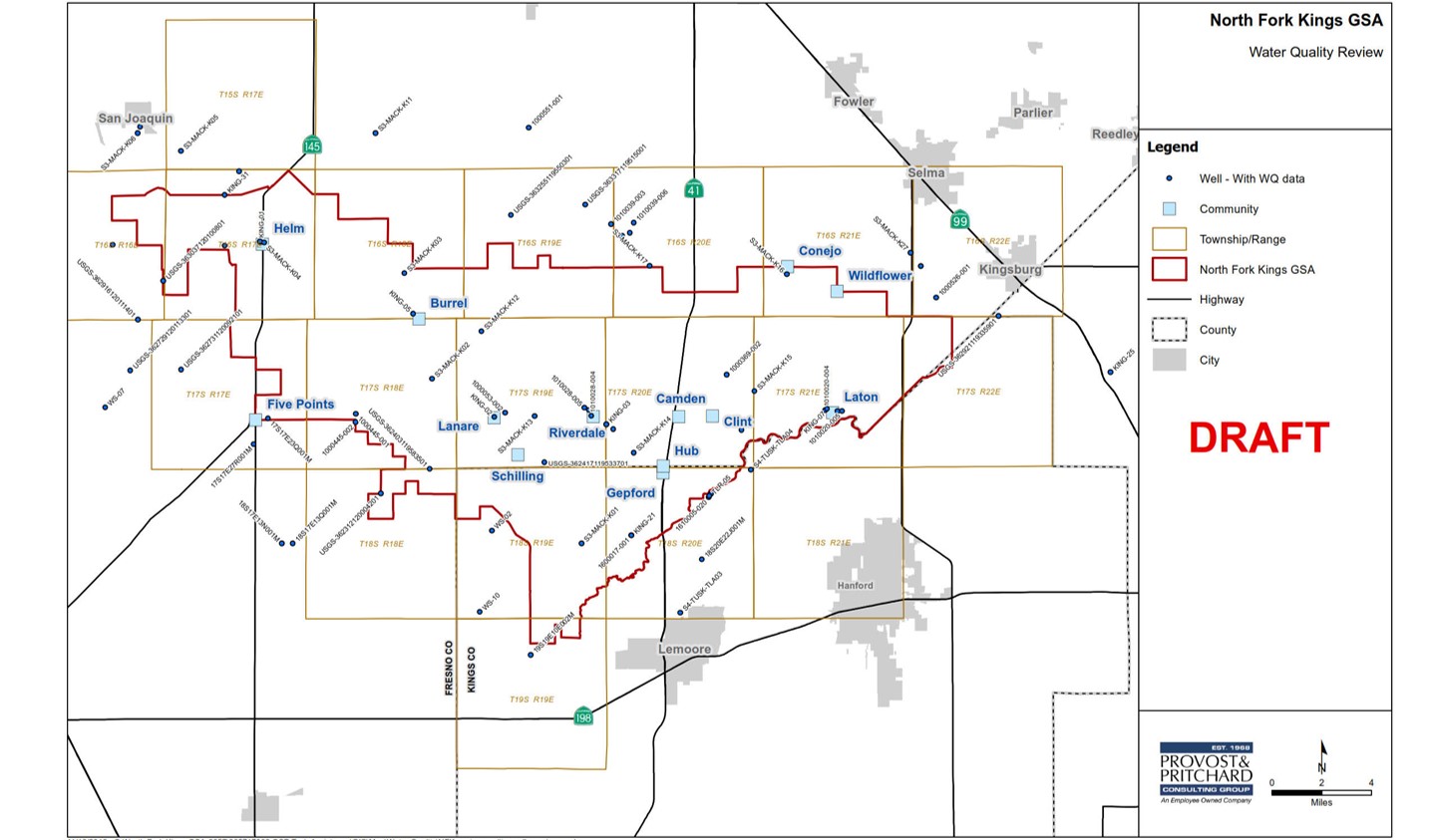
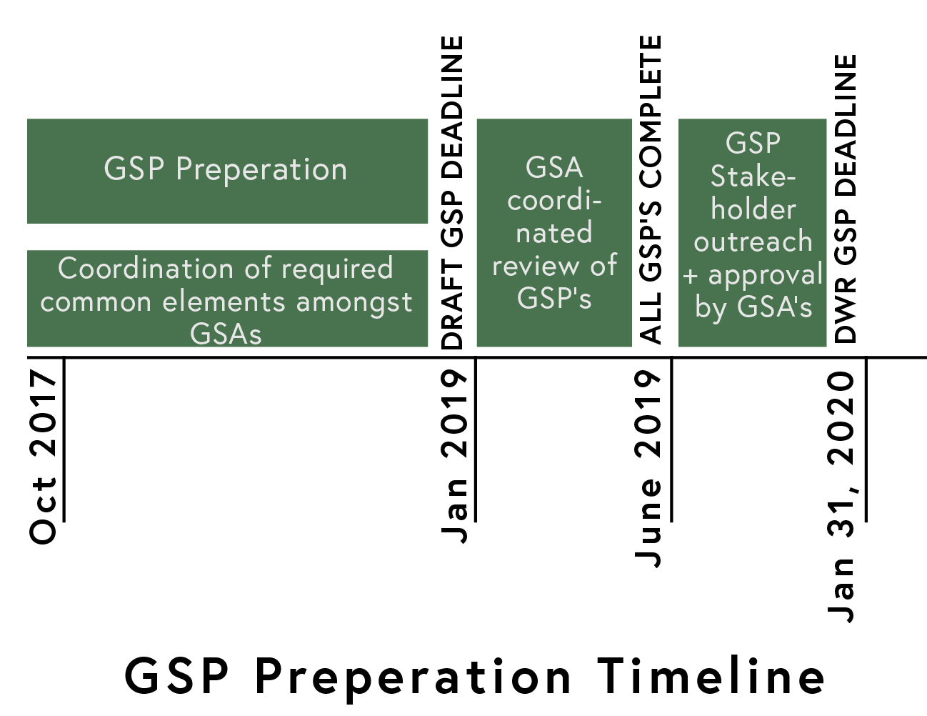
At the April 25th study session, North Fork Kings GSA technical consultant Kevin Johansen of Provost & Pritchard presented on the current status of Groundwater Sustainability Plan (GSP)  development. The presentation outlined technical requirements of the GSP and future milestones, a completed GSP draft by January 2019 being the nearest. The goal is for all GSA’s within the Kings subbasin to complete individual GSP drafts by the January 2019 deadline, leaving enough time to coordinate a comprehensive subbasin GSP. Final GSP’s must be submitted to the CA Department of Water Resources (DWR) by the required deadline of January 2020.

The timeline below indicates target deadlines.


Sustainable Management Criteria

Overview

The Sustainable Management Criteria is one of several Best Management Practices (BMP) guidance documents created by DWR. These documents were created to provide clarification, guidance, and examples to help GSA’s develop the GSP. DWR defines BMP’s as “the practice, or combination of practices, that are designed to achieve sustainable groundwater management and have been determined to be technologically and economically effective, practicable, and based on best available science.” The BMP’s are guidelines for reaching sustainability by 2040 under SGMA.

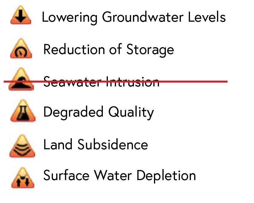
Provost & Pritchard discussed next steps to implement the Sustainable Management Criteria. Sustainability according to the Sustainable Management Criteria is achieved by avoiding “significant and unreasonable” results across six Sustainability Indicators. The consultants are working to coordinate amongst the seven GSA’s within the Kings subbasin to establish a methodology for defining “significant and unreasonable” results across the Sustainability Indicators. Once established, that methodology will be used by each GSA to set goals and define sustainability success. The six Sustainability Indicators are listed below. Seawater Intrusion is not relevant due to geographic location.

The “significant and unreasonable” results (ie. a specified level of groundwater elevation decline that is unacceptable) are defined by the GSA and must be accepted by DWR. The following metrics set by the GSA and approved by DWR serve as the measuring stick of sustainability across the Sustainability Indicators:

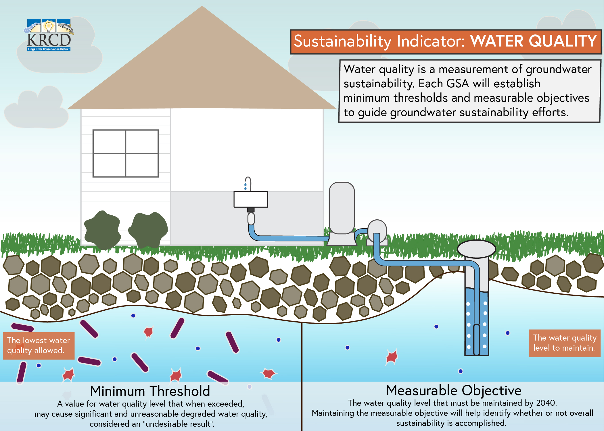
          Minumum Threshold – the lowest result allowed in the worst case scenario. A quantitative value that when exceeded cannot cause an “undesirable result” and thus cannot be an arbitrary                                                               number.

          Undesirable Result – a result defined by the GSA and approved by DWR in line with DWR’s suggested Best Management Practices. Undesirable results will be used by DWR to determine                                                          whether the sustainability goal has been achieved within a basin. Based on minimum threshold exceedances. If caused, sustainability is not successful.

          Measurable Objective – average maintained result over the long-term. Must be met by 2040. Success metric of sustainability across Sustainability Indicators.

Each GSA will set its own results and objectives across the Sustainability Indicators using the methodology coordinated amongst the seven GSA’s in the Kings subbasin. For example, all GSA’s within the Kings Subbasin will use the same methodology to set their groundwater level minimum threshold, but for each GSA the specified level (lowest quantitative groundwater elevation allowed in the worst case scenario) will be different.

Example: Reaching Groundwater Level Stabilization

A closer look at the Sustainability Indicator: Lowering Groundwater Levels, illustrates the path toward sustainability under the Sustainable Management Criteria BMP. The relationship between Lowering Groundwater Levels, undesirable results, and minimum threshold is outlined in the flowchart below.


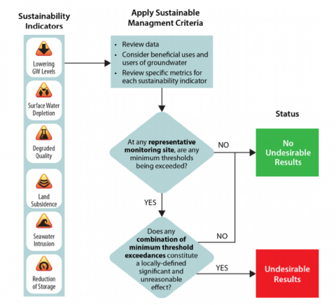
To avoid “significant and unreasonable” results of the Lowering Groundwater Levels, the minimum threshold may not be exceeded to a level that causes undesirable results.

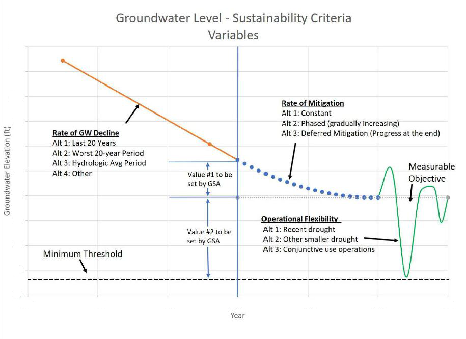
Setting the minimum threshold and measurable objective values for groundwater level sustainability requires a methodology built using three sustainability criteria variables: rate of groundwater declinerate of mitigation, and operational flexibility. The graphic below illustrates these variables in relation to the change groundwater elevation.

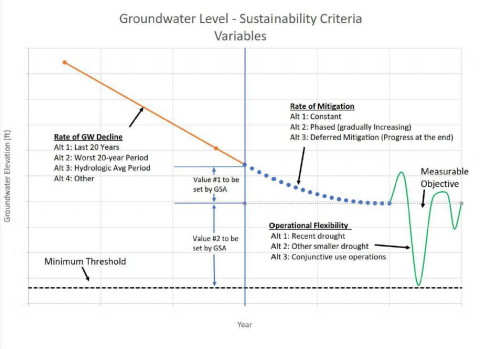
Each variable can be determined a number of ways, and once determined are used in relationship with one another to set quantitative groundwater elevation levels for the measurable objective and the minimum threshold.

Rate of groundwater decline is the rate at which groundwater levels have declined over a set period of time, and can be determined using one of three frameworks:

  1. Look at last 20 years, or
  2. Look at worst 20 years, or
  3. Look at hydrologic average period

Rate of mitigation is the rate at which improvements towards the measurable objective are made, and can be determined one of three ways:

  1. Constant (small, equal improvements each year), or
  2. Phased (slow at first with increased rate of progress over time), or
  3. Deferred mitigation (no progress until last 5 years; not recommended, unlikely to be accepted by DWR)

Operational Flexibility is the range of fluctuation in groundwater level allowed that still maintains the measurable objective average, taking into consideration dry versus wet years. The lowest range level of operational flexibility allowed is equal to the minimum threshold. The range of flexibility can be determined one of three ways:

  1. Recent drought or
  2. Other smaller drought or
  3. Conjunctive use operations (coordinated use of groundwater and surface water)

Provost & Pritchard is working to establish the methodology using the variables above. Using the example of Lowering Groundwater Levels, the technical consultants will recommend how to determine the rate of groundwater decline, the rate of mitigation, and the operational flexibility. The variables will then be used to establish the quantitative groundwater elevations for minimum threshold and measurable objective, and the rate at which the objective is achieved.

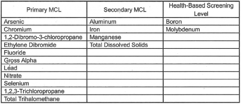
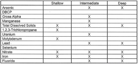
The North Fork Kings GSA will need to establish “significant and undesirable” metrics for each of the five relevant Sustainability Indicators. Realistic minimum thresholds and measurable objectives are key to reaching sustainability outlined by SGMA.

Additional GSP topics covered during the Study Session include the Water Budget, Monitoring Network, Land Subsidence, and the Proposition 218 Election. The full presentation can be found here: NFKGSA Board Study Session PowerPoint 

Translate »