Well Registration
The North Fork Kings GSA is implementing a new Well Registration Program through Watermark, a new online tool for landowners.
Landowners’ prompt action in the well registration program is a key part of keeping local control over groundwater management.
The well registration program is most immediately tied to a State-required groundwater study on the confined aquifer. Over the next several months, the North Fork Kings GSA will conduct this study to better understand land subsidence and groundwater flows. This study is not optional – it is required by the State as part of the North Fork Kings GSA’s implementation of the Sustainable Groundwater Management Act (SGMA). Landowner participation is an important part of completing the study.
Join us at a well registration event!
The North Fork Kings GSA is holding three well registration events to assist with activating your Watermark account. Attend a well registration event to:
- Understand more about the well registration program
- Receive one-on-one assistance
- Ask questions
All events will take place at the Riverdale Memorial District, located at 3085 W Mt. Whitney Ave, Riverdale, CA 93656.
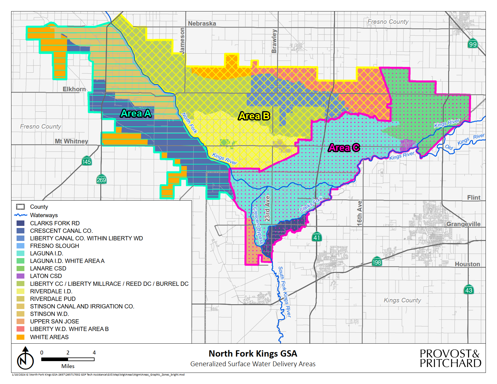
Attend the registration event for your geographic area identified on the map.
If you cannot attend the date for your geographic area, you may attend an alternative date.
Event dates:
Area A – February 21, 2024, 7:30 AM – 10:30 AM
Area B – March 7, 2024, 11:00 AM – 2:00 PM
Area C – March 20, 2024, 7:30 AM – 10:30 AM
Please bring the letter that contains your verification codes and a laptop to receive assistance during the event.

How to activate your Watermark account
BEFORE ACTIVATING YOUR ACCOUNT, HAVE THESE THINGS READY:
1. VERIFICATION CODE(S)
- Starting January 31st, landowners will begin to receive their verification codes in the mail. These verification codes are needed to claim parcels and start the well registration process. If it is after February 9th and you still have not received your letter, or if you misplaced it, please reach out to help@northforkkings.org for assistance.
2. WELL INFORMATION
REQUIRED
- Well location (you will be able to pin it on a map)
- Well name
- Well type
- Well status (active/inactive)
- If there is a flow meter
IF AVAILABLE
- Whether or not you have the well completion report
- Year drilled
- Well driller
- Well depth
- Perforated Intervals/Screen Depth (ft.)
- Pump type
- Pump horsepower
- Whether or not you’ve had a pump efficiency test within the past 3 years
to activate your Watermark account and register your well(s):
1. Visit watermark.mljenvironmental.com and complete the “create an account” form
Account-holders may either own or manage parcels with the North Fork Kings GSA.
2. create a water account(s)
If you manage groups of parcels separately as different farms/ranches or manage separate farms/ranches on behalf of others, you can create separate water accounts. This will be helpful to separately track water use and help with future water allocation management.
3. Add parcels to your account
- Use verification codes to claim your parcels.
- To claim parcels to your account, you must be the parcel owner or contact the landowner to obtain the verification code. Alternatively, you can download the Landowner Authorization Form and submit a signed copy to help@northforkkings.org. A member of our support team will contact you with the required parcel verification codes.
4. register your wells
You must claim parcels before starting the well registration process.
5. View evapotranspiration (ET) data by parcel
You can view monthly ET data (consumed water) for your parcels within Watermark.
Resources
- Watermark Walkthrough Guide
- Step-by-step instructions for activating your Watermark and registering your wells.
- Landowner Authorization Form
- To claim parcels into your Watermark account that are owned by another individual fill out this form and submit to help@northforkkings.org and a member of our support team will contact you with the required parcel verification codes. Landowner signature is required on the form. Alternatively, contact the landowner to retrieve the verification codes they received in the mail.
- Well Registration Flyer
- Well Registration FAQs
Well Registration Workbook – Alternative to registering wells one-by-one
For multiple wells: Use this workbook to register all wells at once. Download, fill it out, and send it to help@northforkkings.org for uploading to your Watermark account. Note: you need to have your Watermark account created and set up the Water Account you’d like them uploaded to.
Why Well Registration?
The well registration program is most immediately tied to a State-required groundwater study on the confined aquifer. Over the next several months, the North Fork Kings GSA will conduct this study to better understand land subsidence and groundwater flows. This study must be completed by fall 2024. Landowner participation in well registration is a key part of the study’s completion and success in maintaining local control over groundwater management.
Well registration also serves as a valuable tool for the North Fork Kings GSA in the pursuit of long-term groundwater sustainability. Gathering information on the number and location of wells, along with other relevant data, is essential for effective groundwater management.
Additionally, this data will contribute to the future domestic well mitigation program by informing the North Fork Kings GSA about the location and number of domestic wells within its boundaries. This proactive approach allows the North Fork Kings GSA to plan for the program adequately, ensuring sufficient resources are available for the well owners involved.
About Watermark

Watermark is an online SGMA tool for growers and residents in the North Fork Kings GSA. Watermark as a well registration tool is only the first step in a long-term vision for the platform. The toll will be developed over time to include water accounting capabilities once groundwater allocations are in place.
For now, landowners can use Watermark to begin tracking their monthly water use by accessing parcel-level ET data. Understanding water use is the first step to being able to plan for water allocations in the future.
