Skip to content Skip to left sidebar Skip to footer

News

Board Adopts, Submits GSP Revisions to State

At the July 14 special meeting, the North Fork Kings Board adopted the revisions to the North Fork Kings Groundwater Sustainability Plan (GSP). The revisions were in response to the Department of Water Resources’ (DWR) ruling that the GSP was incomplete after a two-year review. The North Fork King’s GSP was one of seven GSPs in the Kings Subbasin ruled incomplete.

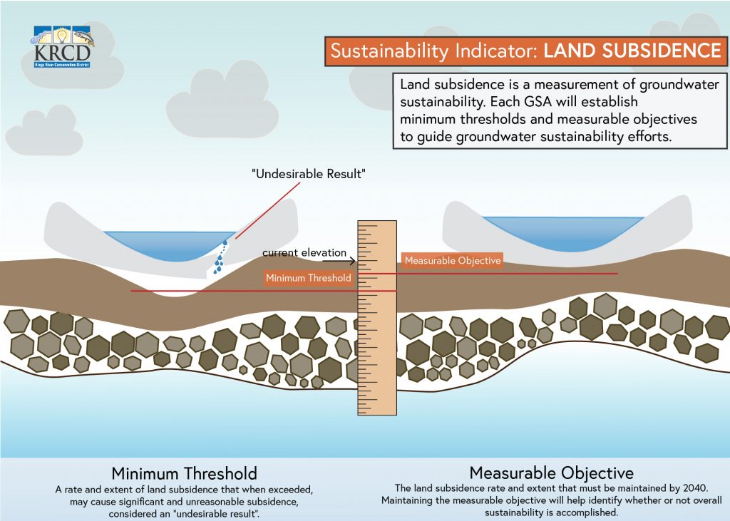
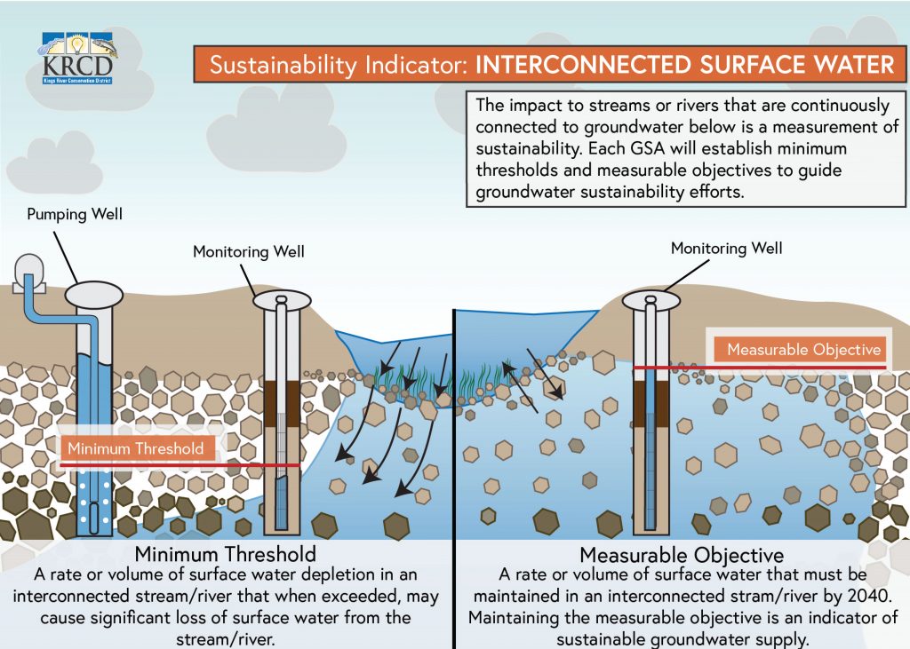
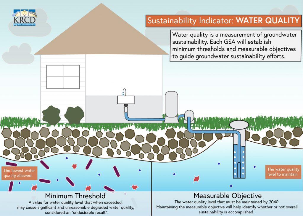
The DWR stated the seven GSPs needed more coordination and consistency and identified several deficiencies. Most of the State’s comments centered around Sustainable Management Criteria which are the quantitative metrics that define sustainable management of a subbasin. The deficiencies covered four main topics: groundwater levels, land subsidence, interconnected surface water, and water quality.

The revised GSPs were submitted to DWR prior to the July 27 deadline. DWR will review the GSPs to evaluate whether the deficiencies were sufficiently addressed. If the GSAs failed to take sufficient actions to correct the deficiencies, the GSPs will not be approved. If this happens, the State Water Resources Control Board has the authority to intervene and take over management of the Subbasin. It is anticipated the State will complete their review no later than early 2023. To view the final revised GSP go to www.northforkkings.org/gspdownload.

Four Main Deficiencies Were Addressed in Groundwater Sustainability Plan Revisions

On January 28, the Kings Subbasin Groundwater Sustainability Agencies (GSAs) were notified by the State that the collective Groundwater Sustainability Plans (GSPs) of the seven Groundwater Sustainability Agencies in the Kings Subbasin were incomplete. The Department of Water Resources (DWR) informed the Kings Subbasin Coordination consultant Provost & Pritchard Consulting Group that the Subbasin’s GSPs did not satisfy the objectives of the Sustainable Groundwater Management Act (SGMA) nor substantially comply with the GSP Regulations. The Kings Subbasin GSAs were required to address the deficiencies and resubmit the GSPs to the Department for evaluation no later than July 27, 2022.

DWR noted that the seven GSPs needed more coordination and consistency and identified several deficiencies that prevented approval of the GSPs. Most of DWR’s comments centered around Sustainable Management Criteria, which are the quantitative metrics that define sustainable management of a subbasin. The deficiencies covered the areas of how lowering of groundwater levels are to be handled; how land subsidence will be identified and handled; the identification of interconnected surface water systems; and sustainable management criteria for possible water quality issues.

The Kings Subbasin Coordination Group, which is comprised of the leadership of the seven GSAs, started working on revisions to the GSPs in February with final drafts completed in June. Each GSA Board is now in the process of adopting their respective GSPs that include the corrections to the deficiencies identified by the State. The North Fork Kings GSA has scheduled a special Board meeting on July 14 to adopt the revised GSP.

Below is a brief summary of the general revisions to the GSPs. To view the complete North Fork Kings GSP revision documents go to www.northforkkings.org/gspdownload.

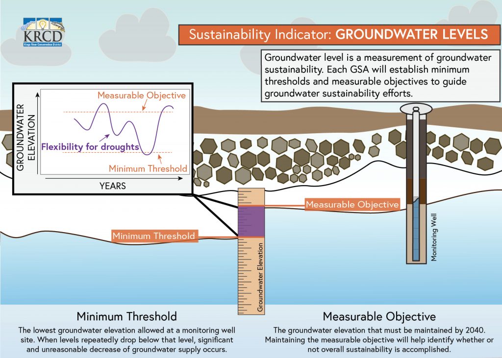
Deficiency 1: GSPs do not set their Sustainable Management Criteria for chronic lowering of groundwater levels in a manner consistent with the requirements of SGMA and the GSP regulations.

Response to Deficiency 1: Changes to the GSPs include discussion that primary concerns related to Undesirable Results for groundwater levels are that groundwater levels will decline in dry periods to a point that they will not likely recover during normal/wet periods and a significant and unreasonable number of shallow domestic wells will go dry. Language was added acknowledging the impact on shallow wells and a shallow Well Mitigation Program has been added to the GSPs. The GSPs also reiterated the significant aquifer in the Kings Subbasin, several hundred feet below current levels with water of suitable quality.

Deficiency 2: GSPs do not set Minimum Thresholds (MTs) and Measurable Objectives (MOs) for land subsidence in a manner consistent with their undesirable result definition and the requirements of SGMA and GSP regulations.

Response to Deficiency 2: Primary concern is loss of capacity in gravity flow water conveyance systems. Changes to the GSPs include focus on impacts on infrastructure on main irrigation canals. The established MT is based on canal capacity. It is recognized that the Subbasin does not have good data on the confined aquifer pumping. One of the programs in the GSPs is to fill that data gap. The GSPs also acknowledge that the Subbasin can only eliminate subsidence within the Kings Subbasin control and that subsidence from other areas is impacting the Kings Subbasin.

Deficiency 3: GSPs do not consistently identify interconnected surface water systems, or provide the location, quantity, and timing of depletions of those systems due to groundwater use. The GSPs do not define Sustainable Management Criteria for the depletions of interconnected surface water in the manner required by the GSP regulations.

Response to Deficiency 3: Much of the language is revised to list this as a data gap. A plan and timeline have been included to gather missing information and determine extent of interconnection, as well as estimate of possible groundwater pumping. Coordination with the San Joaquin River Restoration Program and Kings River Fisheries Management Program were referenced as providing a better understanding of surface water uses/losses along those rivers in order to maintain required flows.

Deficiency 4: GSPs do not provide adequate information to support the selection of degraded water quality Sustainable Management Criteria.

Response to Deficiency 4: Language has been revised to be more specific regarding the determination of Undesirable Results. Water quality data will be collected annually and compared against Minimum Threshold levels. If there is an exceedance, site-specific investigation will be conducted to try to determine if GSA actions have contributed to groundwater quality degradation, and if so, management actions will be implemented.

Once the GSAs resubmit their respective GSPs, DWR will provide a 60-day comment period and then review the revised GSPs to evaluate whether the deficiencies were sufficiently addressed. Should the GSAs fail to take sufficient actions to correct the deficiencies identified by the DWR, the GSPs will not be approved. If this happens, the State Water Resources Control Board has the authority to intervene and take over management of the Subbasin. DWR anticipates they will complete their review of the GSPs and provide a ruling no later than early 2023.

Board Hires New General Manager

The North Fork Kings Groundwater Sustainability Agency Board approved the hiring of Justin Mendes as their new General Manager at the May 25 Board meeting.

“I am happy to hire Justin to tackle the many issues in front of the North Fork Kings GSA,” stated Board Chair Mark McKean.

Justin was raised in Riverdale, graduating Riverdale High School in 2004. Justin comes to the GSA most recently from Tulare Lake Basin Water Storage District handling government and regulatory affairs. Before that, Justin spent over 10 years as a District Director for the U.S. Congress and the State Assembly; specializing in constituent services and community outreach. 

Board Update on Governor’s Executive Order and GSP Revisions

Governor’s Executive Order

During the last few weeks, the North Forks Kings Groundwater Sustainability Agency (North Fork Kings GSA) has been working with Fresno and Kings counties to address the Governor’s Executive Order N-7-22. Governor Newsom declared that groundwater sustainability agencies will start reviewing well permits with consideration of the well’s effect on the groundwater sustainability plan. North Fork Kings GSA has designed a process to review well permits that would not cause significant delays to well drilling schedules. Upon review and approval of the well, the North Fork Kings GSA will send a notification stating that the well cannot have “detrimental effects” and “undesirable results” on the neighboring wells in the area. For more information on North Fork Kings GSA’s process, contact us at (559) 242-6118.

Groundwater Sustainability Revisions

The North Fork Kings GSA is currently working to address comments from the Department of Water Resources (DWR) on the North Fork Kings Groundwater Sustainability Plan (Plan) that determined the Plan to be insufficient. The DWR identified several deficiencies that prevented approval of the Plan. The deficiencies covered the areas of how lowering of groundwater levels are to be handled; how land subsidence will be identified and handled; the identification of interconnected surface water systems; and sustainable management criteria for possible water quality issues. The Kings Subbasin GSAs are coordinating to revise all the Plans in order to have more common language and consistency. The revisions are due to DWR at the end of July which will then be open for public comments for 60 days before DWR begins its review.

              In addition to addressing the comments from DWR, the North Fork Kings GSA Board approved signing on with other groundwater sustainability agencies in the Kings Subbasin to a letter addressed to Deputy Director Karla Nemeth of the Department of Water Resources. The letter is in response to DWR’s determination that all groundwater sustainability plans in the subbasin are incomplete. This letter specifically addresses DWR’s comments with regards to groundwater levels and the verbal reference by DWR that any single well that goes dry is significant and unreasonable. The letter states that this limits the groundwater sustainability agencies in the Kings Subbasin ability to have local control to decide what is significant and unreasonable and that it is not within the requirements in the Sustainable Groundwater Management Act for the groundwater sustainability agency to be responsible for ensuring that no rural residential well goes dry.

Determining Groundwater Use

There are two basic ways to determine the amount of groundwater used by each landowner: (1) measuring the volume of groundwater pumped by using a flowmeter on the well, or (2) through crop evapotranspiration information obtained via satellite technology. A flowmeter installed on a well measures the gross or total amount of groundwater pumped, whereas the net amount of consumed groundwater can be determined through calculations using crop water use data. The gross amount of water pumped will exceed the net consumptive use because of inefficiencies in the irrigation system.

The North Fork Kings Groundwater Sustainability Agency (NFKGSA) has recently hired a consultant that utilizes satellite data, cropping data, and local weather stations within the NFKGSA to calculate, by field and by parcel, the amount of water consumed by the crop each month. The actual cropped acreage of a field is identified along with the crop itself. This data is available approximately 30 days after the end of each month. After accounting for surface water deliveries to the field and the amount of precipitation used by the crop, the amount of consumed groundwater can be obtained. At this time, the NFKGSA is using the crop consumptive use information to calculate groundwater use and is only requiring flowmeters to be installed on new wells, but all groundwater wells within the GSA may be required to measure groundwater extraction by flowmeters at some point in the future.

The maps below represent the amount of water consumed by fields in the GSA for the months June, July, and August 2021. Measuring water consumption and calculating groundwater use allows the NFKGSA Board to effectively track progress and make management decisions to achieve groundwater sustainability as required by State law. These maps that allow you to view your measured water use are located at www.northforkkings.org/maps. Additional information on how the crop consumptive use information will be used will be provided to all landowners in the near future.

Kings Subbasin Builds for Drought Resilience at Record Pace

15 basins representing 600 acres of prime groundwater recharge land with a singular goal of groundwater sustainability

Click here to view the StoryMap outlining project details, locations, and more, and to view the highlight video.

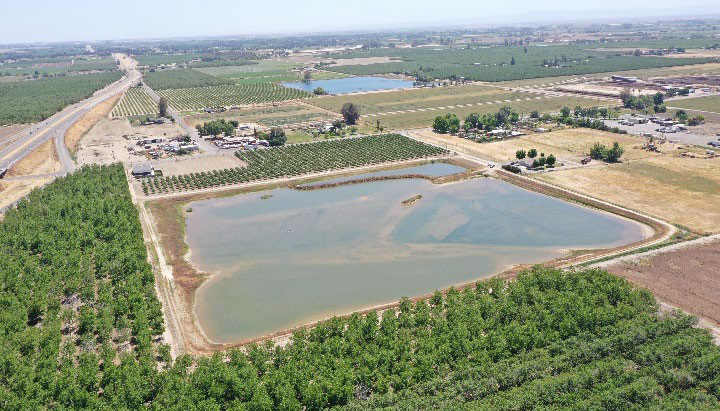
In the short span of two years, the Kings Subbasin Groundwater Sustainability Agencies, including the North Fork Kings GSA, have invested in 600 acres of prime groundwater recharge land. This land represents 15 dedicated basins that are constructed or in development.

Local water managers have taken the long view as they invest in infrastructure now with the goal to bring sustainability to the groundwater supply shared by all within the Kings Subbasin region.

The additional water infrastructure is anticipated to provide over 15,000 acre-feet of recharge per year on average, directly benefitting groundwater levels for communities and ag lands in the area. An acre foot equals 325,900 gallons, or enough water to cover a football field to a depth of one foot.


View Full StoryMap

Project highlights, videos, locations, and more.

StoryMap


Since the Kings Subbasin submitted seven Groundwater Sustainability Plan Plans (GSP) in January 2020, there has been a driven effort to successfully build groundwater recharge capacity to support Kings Subbasin sustainability goals.

The North Fork Kings GSA has worked diligently alongside its subbasin neighbors to contribute to these efforts. Since GSP adoption, member agency Laguna Irrigation District (ID) has expanded and improved its existing Basin 11 project. Cooperation with water districts like Laguna ID and local landowners has catalyzed construction on several additional projects that in total will bring over 7,000 acre-feet of increased recharge capacity to the area.

Laguna Irrigation District Basin 11 Improvement & Expansion Completed

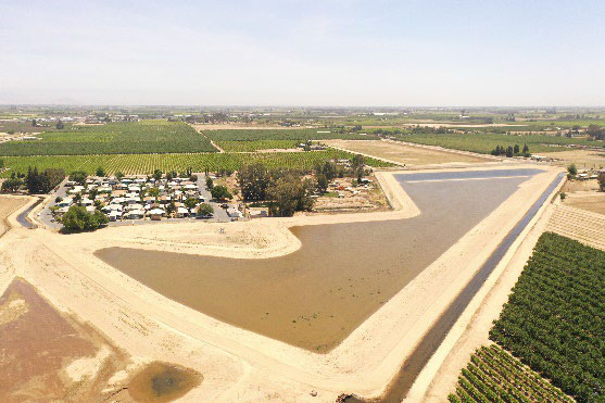
The Laguna Irrigation District Basin 11 Improvement project consisted of the development of a groundwater recharge basin on a 52-acre site using Kings River floodwater as the primary water source.

This project increased conveyance capacity of the Liberty Canal, constructed a basin with exterior levees, a settling channel, a check structure and headworks to divert water, and installed flow meters and monitoring wells. The project was recently improved through excavation to increase water infiltration resulting in more water being recharged.

The Basin 11 Expansion Project was completed in 2019, adding 38 acres to the project.

Regulation for wells, groundwater usage

The North Fork Kings GSA Board adopted Rules and Regulations in December 2020 to sustainably manage groundwater within the GSA boundary. These regulations, which will be periodically updated, are necessary to implement solutions that will provide a groundwater supply buffer for landowners to use during drier years. The regulations cover topics such as registration of wells, installation of flowmeters, groundwater usage, fees, and storage of groundwater. You can review these rules on the Board Policies webpage.

Here is a brief overview of each of these:

Individual Recharge

A landowner may use existing facilities to store surface water underground within the North Fork Kings GSA boundary and can then put that water to their own beneficial use within the GSA boundaries. The GSA is currently developing the process for growers to participate in an individual recharge program.

Well Registration

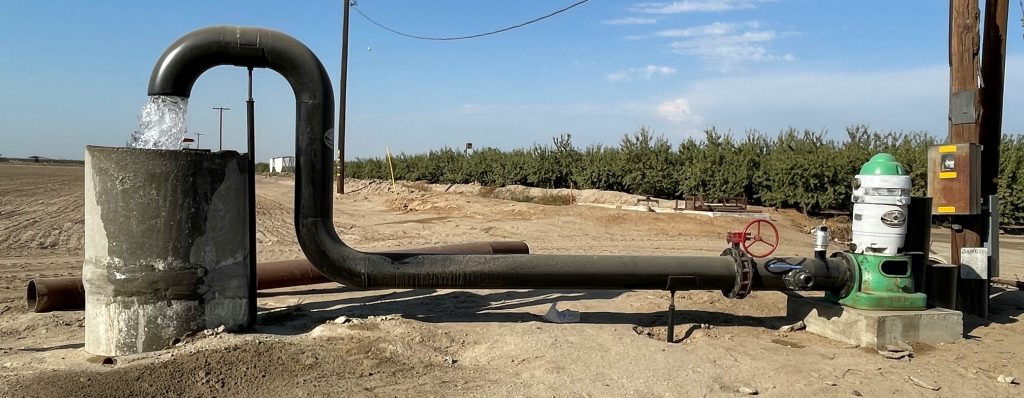
Any new wells constructed after January 31, 2021 must be registered with the North Fork Kings GSA within 30 days of drilling completion. All new wells must also install a flowmeter at the time of construction. Metering wells will allow the North Fork Kings GSA to have reliable, accurate extraction data to more effectively track progress and achieve sustainability goals.

All existing wells owned by landowners who own sixty or more acres within the North Fork Kings GSA boundary need to be registered with the North Fork Kings GSA by July 1, 2022. All other wells must be registered by January 1, 2023.

Criteria for Using Meters

All new extraction wells, excluding de minimis users (a person who extracts 2 acre-feet per year or less of groundwater for domestic purposes) are required to be measured by flowmeters and all costs associated with the purchase, installation, operation and maintenance of flowmeters shall be borne by the owner or operation of each extraction facility. In the future, the North Fork Kings GSA may require flowmeters on all non-de minimis wells.

Groundwater Usage

Currently, the North Fork Kings GSA is utilizing satellite imagery, needs analysis, local precipitation and surface water accounting to determine pumping in the region. This technology along with meter information is necessary to develop an accurate water balance for the region. Technical groups are developing future groundwater allocations which are necessary to balance groundwater supplies.

Fees & Assessments

The North Fork Kings GSA is funded through land-based assessments that are included on County property tax bills. North Fork Kings GSA landowners voted to allow a maximum $10.00 per acre assessment in order to locally manage groundwater. In the future, groundwater pumping fees may be necessary to build recharge ponds to replenish groundwater in rainy years.

If the North Fork Kings GSA is unable to locally fund the implementation of SGMA and achieve groundwater sustainability, the State could step in and impose a fee structure on groundwater pumpers many times more costly than the North Fork Kings GSA. They, the State, will also regulate how much groundwater a landowner can pump.

Terra Linda Fruit Avenue Recharge Project Completed

The recently completed Terra Linda Fruit Avenue Recharge project is an 80-acre Landowner Project within the Liberty Mill Race Company service area of the North Fork Kings GSA. The project included construction of above ground levees and installation of headworks and structures for three lift pumps. A generator backup, to keep water flowing in the event of power outage, will soon be installed.

All surface waters for the project will be supplied by Liberty Mill Race Company in the form of its Pre-1914 water supply during flood events.

The North Fork Kings GSA will continue to implement innovative projects that will lead to a resilient supply of groundwater in the region while working to keep groundwater management local.

Board approves $10 per acre assessment

At the May 26 Board Meeting, the North Fork Kings GSA Board approved a maximum assessment of $10 per acre for Fiscal Year 2021-22. The fall county tax rolls will include the assessment. This means if a landowner owns 100 acres, the amount that will be due to the North Fork Kings GSA in Fiscal Year 2022 is $1,000. There are 163,653.7 assessable acres in the North Fork Kings GSA. Based on the assessable acres, this generates $1,636,537 of projected revenue for implementation.

With the adoption of the North Fork Kings GSA’s Groundwater Sustainability Plan in January 2020, the budget focuses on implementation projects and programs that will achieve groundwater sustainability.

Translate »