Skip to content Skip to left sidebar Skip to footer

Author: Cristel Tufenkjian

Kings Subbasin community residents and GSA leaders gather for groundwater discussion in Riverdale

Panelists discuss complexity of the nearly 1 million acre service area

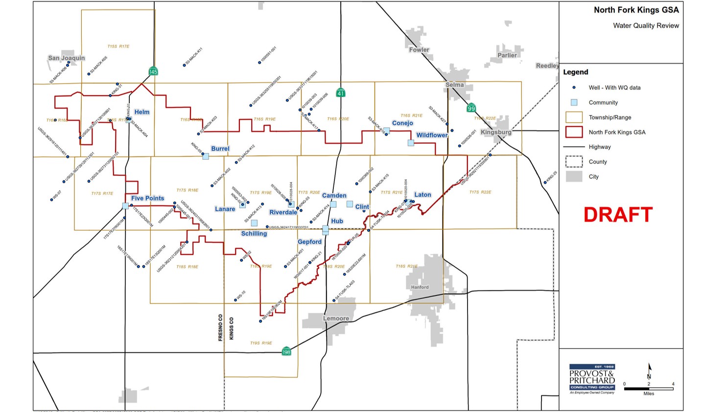
June 10, Riverdale – A community discussion on groundwater and the Sustainable Groundwater Management Act (SGMA) highlighted the complexity of the groundwater Subbasin that covers nearly 1 million acres and gave attendees a better understanding of how groundwater quality will be monitored in the Kings Subbasin.

GSA leaders representing five Kings Subbasin GSAs participated in a panel discussion, emphasizing the feat to coordinate and map out groundwater conditions in a Subbasin that includes 7 GSAs. Panelists included Gary Serrato, Executive OfficerNorth Kings GSA; Matt Hurley, General ManagerMcMullin Area GSA; Steven Stadler, Administrator , James Irrigation District GSA; Mark McKean, ChairNorth Fork Kings GSA; Chad Wegley, AdministratorKings River East GSA; and Ronald (Ronnie) Samuelian, Kings Subbasin Coordinator and Principal EngineerProvost & Pritchard Consulting Group.

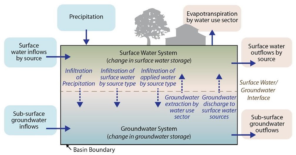
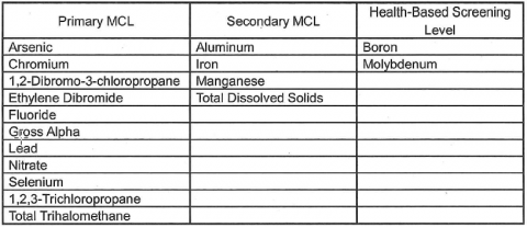
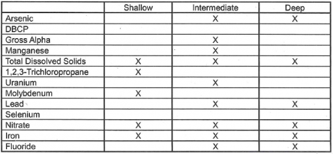
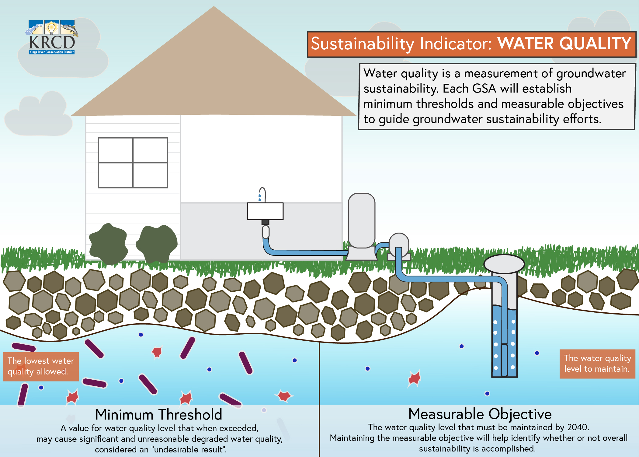
Panelists discussed their plans to monitor water quality as it relates to groundwater pumping. Under SGMA, GSAs are required to ensure water quality degradation resulting from groundwater pumping is not significant and unreasonable. The Kings Subbasin GSA leaders emphasized water quality concerns are localized and must be individually looked at due to high variability; there is no one-size-fits-all management tool or threshold for the Subbasin.

Panelists also noted the GSAs will be looking for changes in trends, not one-time spikes in water quality measurements, to determine if there is a water quality concern that needs to be addressed. The GSAs have outlined a network of wells that will be used to monitor water quality moving forward. In many cases this well network is similar to the network used by existing water quality regulating programs, such as the Irrigated Lands Regulatory Program that monitors nitrates for irrigated agriculture.

Additional workshop topics included an overview of SGMA, groundwater conditions in the Kings Subbasin, and why it is important for rural communities to participate in groundwater planning. The workshop was hosted by the Kings River Conservation District in association with Self-Help Enterprises.

Our water needs a budget

Water is scarce. Sustainability of the resource we all depend on requires balanced inputs and outputs. Whether SGMA is the compulsion or not, responsibly managing water demands a budget.

In the Kings Subbasin we’re working to balance an overdrafted water “account”. The North Fork Kings GSA, along with the six other GSAs in the Kings Subbasin, is required by SGMA to bring its account into balance by 2040.

A water budget, required in the Groundwater Sustainability Plan (GSP),  provides valuable insight for those managing our water. It informs current conditions and will measure impact of the North Fork Kings GSA’s upcoming sustainability efforts.

The budget tracks water inputs and outputs to calculate the change in groundwater storage in the service area. A negative groundwater storage indicates overdraft.

Groundwater Storage = Inputs – Outputs

Sustainability can be achieved by increasing water supply (inputs) and/or decreasing water demand (outputs). The GSP will define how the North Fork Kings GSA plans to balance its estimated 50,300 AF of annual overdraft. The GSA can increase its inputs, decrease its outputs, or a combination of both through projects and management actions. For example increasing inputs through flood water capture off the Kings River in wet years can offset irrigation outputs, bringing the budget closer to balance.

Inputs are water sources, and can include additional surface water, precipitation, estimated groundwater pumping, and groundwater inflow. Outputs are water uses, and can include irrigation, municipal, residential, and industrial uses, as well as groundwater outflow. The North Fork Kings GSA is committed to prioritizing supply side solutions for sustainability.

Water Budget Diagram

click to enlarge

A water budget is a key component of the Groundwater Sustainability Plan (GSP), and will be included in the draft document scheduled for public review beginning in July.

Stakeholders invited to FOX26 SGMA Town Hall

Stakeholders in the North Fork Kings GSA are invited to take place in the upcoming KMPH FOX26 live Town Hall: Groundwater Sustainability Act. Board Chair, Mark McKean, will represent the agency and its co-sponsor MAGSA as a panelist for the event.

The Town Hall will take place this Thursday, May 23 from 6:00-7:00 pm. Stakeholders are invited to join the audience in-person at the Clovis Veterans Memorial District, 808 4th St., Clovis, CA, or watch from the comfort of their homes. The event will air live on FOX26 from 6:00-7:00 pm and will be streamed live on KMPH.com and the FOX26 mobile app.

Panelists include:

  • Mark McKean, North Fork Kings and McMullin Area GSAs
  • Gary Serrato, North Kings GSA
  • Johnny Amaral, Friant Water Authority
  • Mario Santoyo, San Joaquin Valley Water Infrastructure Authority
  • Thomas Esqueda, California Water Institute

The panel will be moderated by news reporter Rich Rodriguez. Viewers will be able to submit questions for the panel using a special text number.

When Water Supply is Scarce, Management Actions can Mitigate Overdraft

There are only two ways to achieve sustainability and eliminate groundwater overdraft for the North Fork Kings service area: increase water supply, primarily through project development and reduce water demand, primarily through management actions. The NFKGSA Board is emphasizing increasing water supply with the understanding there are hurdles to overcome.

The preliminary project list continues to be updated and contains recharge projects that would yield an estimated annual average of approximately 50,000 acre feet per year based on historic floodwater availability. The seven Kings Subbasin GSAs have reached agreement on an initial overdraft amount for the entire Kings Subbasin of 122,000 acre feet. The North Fork Kings GSA estimated amount of the 122,000 acre feet is 50,300 acre feet. 

The amount of overdraft that cannot be overcome with increasing the water supply will need to be overcome with management actions that reduce water demand.  Demand reduction through management actions will likely need to be initiated within 5 – 10 years if project development isn’t progressing as needed.

Management Actions are programs and policies that will aid the GSA in achieving sustainability primarily through water demand reduction measures and improving data monitoring.  A suite of potential management actions will be presented in the GSP that could be implemented at the GSA level or landowner level. The GSA may not want to dictate management actions at the landowner level, what works for one landowner may not work for another and economic impacts must be considered.

Below are potential management actions that will be considered in the GSP and the estimated time for implementing those actions.

Management Actions for the 2020-2025 Timeframe


click to enlarge

Management Actions for the 2025-2030 Timeframe


click to enlarge

Management Actions for the 2030-2040 Timeframe

click to enlarge

Discussions and the development of the management actions details will begin after the adoption of the GSP in January 2020.

Proposed project would recharge an estimated 15,000 AF annually in the North Fork Kings GSA

A portfolio of solutions will be considered to achieve sustainable groundwater under SGMA. Projects and management actions can work in tandem to augment water supply and reduce water demand, stabilizing groundwater levels. The North Fork Kings GSA Board’s first priority is implementing projects to increase water supply in the service area. The North Fork Regional Recharge Project introduced by Kevin Johansen, Provost & Pritchard, aligns with that priority. The project is in early conceptual stages.

Three groundwater recharge basins with estimated annual recharge capacity of 15,000 AF (acre-feet) are included in the project scope, leveraging suitable recharge conditions in the GSA’s northeast region. The average annual cost per AF of recharge is $160 according to preliminary project cost estimates. The project includes two new basins and expansion of an existing Laguna Irrigation District basin. An additional component needed is improvement and expansion of Liberty Canal to increase current carrying capacity and secure water delivery.

Surface soil type, absence of clay layers, and groundwater flows at project sites are highly conducive to recharge that benefits the entire GSA’s service area. The bulk of surface soils at proposed sites are coarse sands and sandy loam, ideal for percolation into the groundwater aquifer below. And although much of the GSA is underlain with clay layers, the northeast region is absent of these layers. Because groundwater generally flows east to west in the GSA, the groundwater recharged by the project would flow into the rest of the service area. This includes to disadvantaged communities of Lanare and Riverdale where soil type and clay layers are unsuitable for recharge projects.

(click map images to enlarge)

To help cover project cost, the North Fork Kings GSA is pursuing grant funding through Integrated Regional Water Management (IRWM) Prop 1 Implementation funds. A pre-application was sent to the Kings Basin Water Authority for review and if selected, will compete for funding from a pool of $12.7 million for the Tulare Kern Funding Area.

Board Meeting March 27, 2019 at 5:30 pm

The North Fork Kings GSA Board of Directors meeting is scheduled on Wednesday, February 27, 2019 at 5:30 pm. The Board will meet in the Riverdale Community Education Center Board Room, 3160 W. Mt. Whitney Ave., Riverdale, Ca 93656.

Update on water quality in the North Fork Kings GSA, consultant reviews the data

The latest Groundwater Sustainability Plan (GSP) update from the North Fork Kings GSA technical consultants lends insight into the current water quality condition in the GSA service area. Water quality is an indicator of groundwater sustainability. The North Fork Kings GSA will establish sustainability criteria for water quality in its GSP, defining the level of water quality that must be maintained by 2040.

The analysis of water quality data reveals despite lowering groundwater levels, water quality contaminant levels have not worsened over time. But exceedances in maximum contaminant levels (MCL’s) do exist in some areas.

The GSA’s consultant conducted an analysis of publicly available Groundwater Ambient Monitoring and Assessment Program (GAMA) data from 73 wells located in the GSA. This analysis focused on the most recent 10-year period, with some earlier historical data included when available. The black circles on the map below indicate wells with water quality data used in the analysis.

Water Quality Monitoring Network
(click to enlarge)

The water quality data drawn from the wells in the North Fork Kings GSA was measured against the Environmental Protection Agency’s (EPA) primary maximum contaminant levels (MCL’s) and secondary MCL’s. Contaminants without MCL’s were measured against health-based screening levels.

EPA’s primary MCL: legally enforceable standards that apply to public water system and protect public health by limiting levels of contaminants in drinking water

EPA’s secondary MCL: non-enforceable guidelines regulating contaminants that may cause cosmetic effects or aesthetic effects. This is the EPA’s recommended standard, but is not required

The water quality data can be analyzed two ways: by contaminants’ level of exceedance (Table 1) or by existence of contaminants in aquifer “zones” (Table 2).

Table 1
contaimants’ level of exceedance
Table 2
contaminant existence by zone

Existing clay layers in the North Fork Kings GSA allow the division of three conceptual aquifer “zones”: 1) the shallow zone exists from 0-150 feet below ground surface, 2) the intermediate zone exists from 150 feet below ground surface to the base of the unconfined aquifer, and 3) the deep zone exists below the unconfined aquifer. Table 2 above shows that there is not necessarily one zone with water quality exceedances more problematic than another.

Each contaminant’s existing levels can be analyzed individually using separate maps for each aquifer zone. The maps indicate contaminant levels with green, yellow, and red markers. Green indicates contaminant levels are less than half of the MCL. Yellow indicates contaminant levels are more than half or approaching the MCL. Red indicates contaminates are in exceedance of the MCL.

Case Example: Arsenic

Shallow

Image 1 of 3

Click images to enlarge.

The maps show that there are more arsenic MCL exceedances in the intermediate zone, with exceedances concentrated near the center of GSA.

Case Example: Nitrates

Shallow

Image 1 of 3

Click images to enlarge.

The nitrate maps indicate few MCL exceedances in the shallow zone, only a couple in the intermediate, and a single instance in the deep zone.

Understanding water quality in the GSA through data analysis is a key step toward setting metrics that guide the North Fork Kings GSA sustainability efforts and indicate success. Water quality is a sustainability indicator; the GSA will establish a measurable objectives for water quality that quantify the level to maintain by the year 2040.

(click to enlarge)
Translate »